Curving through the Aegean Sea and rugged hills, the Palia Strata provides an impressive route across the island of Amorgos, located in the Eastern Cyclades. This challenging yet memorable trek allows each step to uncover a landscape that remains wild and unspoiled.
The Palia Strata, a donkey path winding alongside the cliffs
On Amorgós, in the
Cycladic archipelago
The Palia Strata trail connects Chóra with Langada, traversing the island’s dry terrain and fertile hills emerging from the Aegean Sea. This ancient route has been traditionally utilized by shepherds to access remote settlements, running along the crest before slowly descending toward northern communities. Over a distance of 14.5 kilometers, you will travel through a network of dirt trails, terraces, empty highlands, and old agricultural properties. The blend of ocean vistas and interior landscapes turns this into one of the most enchanting hikes available in the Cyclades.
Beginning in Chora, at the center of the Amorgos mountains
The journey begins at Chora, situated 400 meters above sea level, located in the hilly heart of Amorgos. The trail starts from the main road heading toward the coastline, climbing old stone steps. Soon, structures transition into short walls, along with clusters of prickly pears and juniper bushes. From here, the Aegean Sea becomes visible below. The route gradually descends, passing through deserted farming areas and rocky enclosures, alongside some lone chapels, until arriving at a cliff face offering views of the southeastern shoreline.
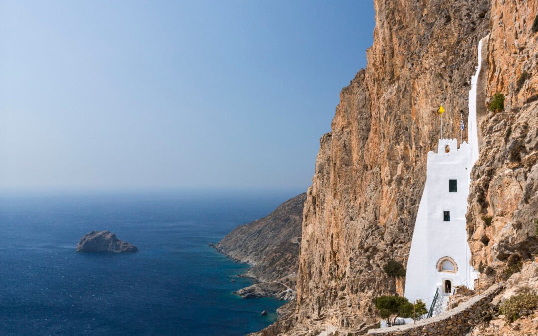
Chozoviotissa, a monastery situated above the ocean
After two kilometers, the trail arrives at
one of the most remarkable places in Amorgos
The Monastery of Chozoviotissa. Constructed in the 11th century.
th
A monastery perched on a cliffside, accessible through a steep staircase etched into the rock 300 meters above the ocean — the sense of solitude intensifies with each step upward. Within, a slender chapel, several small rooms, and some Byzantine icons bear witness to a continuous spiritual tradition spanning nearly a millennium. From the balcony, the panorama extends over the Aegean Sea, encompassing the islands of Nikouria and Keros to the north.
From Kapsala to Asfondilitis, following the path of Amorgos’ shepherds
Following the monastery, the Palia Strata heads further northeast. The trail ascends across rocky ground and passes the remains of Kapsala, once a high-elevation settlement featuring some ruined sheep pens. You will then arrive at Asfondilitis, an empty village famous for its dry-stone walls and simple carvings. From 1897 until 1943, a lone herdsman named Michalis Roussos chiseled images of women, flower patterns, crosses, and names onto the flat stones along the road.
While descending towards Potamós, a terrace offers a view of the Bay of Aegiali
The path follows the coastal road before easing into a more gradual climb as you near Potamós, a small settlement perched above the Bay of Aegiali. The scenery slowly transforms here, featuring short, neatly maintained stone walls, stepped agricultural areas, and clusters of olive trees. Down below, the harbor of Aegiali and its whitewashed homes create a busier section of the region. Potamós stays a peaceful hamlet, boasting some meticulously renovated buildings, tight stairways, and unbroken vistas across the northern hillsides of the island.
Last part of the coastline approaching the village of Langada
The final part traces the shoreline along a terrace all the way to Langada, located on the northeastern shore of Amorgos. As you follow the incline, you encounter groves and some farmland. The village gradually becomes visible, situated on the hillside and overlooking Mount Krikellos. Charming and famous for its great eateries, Langada maintains its classic design, featuring stone-paved roads, steps, and tiny churches. From the central plaza, you may descend towards the Araklos Gorge or ascend to the walled church of Agía Triáda perched atop a cliff.
Key details to consider before departing
The Palia Strata trail is ideally hiked from April through October, when the weather is most suitable. Plan for an outing lasting anywhere between four and a half to five and a half hours, based on your walking speed and how often you stop. The path isn’t consistently marked, making it advisable to carry a map or utilize a GPS application to ensure you remain on course. During summertime, temperatures along this route can rise rapidly without any shelter or access to water sources. Starting your journey early in the day, preferably before 9 am, helps you escape the peak heat. Wearing appropriate shoes is crucial too, since certain parts of the trail are quite narrow, others are steep, and many areas may be slick because of worn-out stone surfaces.
Amorgós
www.amorgos.gr