by admin | Sep 17, 2025 | disaster management, disasters, emergencies, flooding, news
Released on, Aug. 27 — August 27, 2025 at 12:50 PM
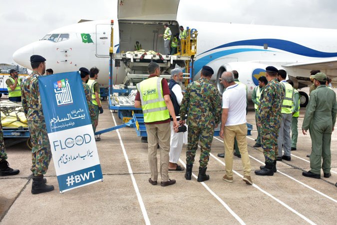
Officials have released an urgent flood alert for the Chenab River near Khanki after water flow surpassed 1,000,000 cusecs early on Wednesday.
The National Disaster Management Authority (NDMA) stated that the Khanki headworks were built with a maximum capacity of 800,000 cusecs, prompting worries that surplus water might harm the structures if the level keeps increasing.
The NDMA issued a warning that the rising waters present a significant danger to surrounding neighborhoods, particularly those located in low-areas near the riversides, and advised locals to stay vigilant and adhere to safety guidelines.
Authorities highlighted that emergency crews are keeping a close watch on the river and are prepared to carry out search and recovery efforts to safeguard people and assets in impacted areas.
Authorities local are urging residents near the Chenab River to leave right away and go to specified secure areas and flood shelter centers to ensure their safety.
The NDMA also advised locals to assemble emergency supplies containing necessities like food, water, medication, and crucial papers, while steering clear of non-essential trips close to the overflowing river and its smaller streams.
by admin | Aug 29, 2025 | disaster management, disasters, emergencies, flooding, news
Released on, Aug. 19 — August 19, 2025 at 11:02 AM
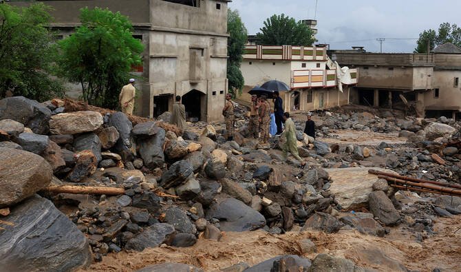
Intense monsoon downpours have caused rivers in Punjab to rise to alarming levels, submerging communities, damaging agricultural land, and isolating areas due to blocked roadways, with the NDMA issuing a critical warning about impending rainfall.
A warning was issued as Khyber-Pakhtunkhwa experienced severe floods that resulted in more than 320 fatalities. Prime Minister Shehbaz Sharif instructed his ministers to take direct responsibility for overseeing aid efforts in the most severely impacted areas.
Beginning in late June, continuous heavy rains, sudden floodwaters, and mudslides have resulted in the deaths of at least 657 individuals and injuries to almost 1,000 others throughout Pakistan. Authorities worry about deteriorating situations with additional rainfall expected.
The National Disaster Management Authority stated that intense to extremely high amounts of rain are anticipated throughout Punjab, Khyber Pakhtunkhwa, Sindh, Balochistan, Azad Jammu and Kashmir, and Gilgit-Baltistan. Authorities cautioned that precipitation could surpass 50 to 60 percent over typical rates.
K-P continues to be the most severely affected area, with regions such as Buner, Swat, Shangla, and Bajaur experiencing extensive damage. Many houses have suffered destruction or harm, and roadways and bridges are still obstructed due to landslides.
At the same time, rescue efforts are being carried out. The NDMA along with regional authorities are providing tents, quilts, provisions, and monetary assistance. The Prime Minister pledged to the individuals affected by floods that their damaged houses will be reconstructed and security protocols enhanced.
by admin | Aug 19, 2025 | disasters, emergencies, news, rain, rainfall
Released on, Aug. 19 — August 19, 2025 at 1:52 PM
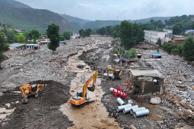
Heavy rains in northern China have claimed at least 13 lives, with five people still missing, as authorities struggle to manage extreme weather that shows no sign of stopping soon.
State media reported that three bodies were recovered from floodwaters in Ordos, Inner Mongolia, while three others went missing near the banks of the Yellow River, roughly 70 kilometers away.
Monday’s downpour, the first of three consecutive storms forecast in the region, dumped more than 204 mm of rain in less than 24 hours, exceeding August’s monthly average by over double.
Earlier, on Saturday, a flash flood swept through Bayannur’s grasslands after a river burst its banks, killing at least ten people and leaving 13 campers stranded; one was rescued while two remain missing.
Search efforts by rescue crews persist in Ordos, close to Baotou—a key center for rare earth minerals—amid severe rain and floods posing risks to facilities and potentially forcing many from their homes.
Weather experts caution that intense precipitation connected to global warming presents increasing difficulties for officials, straining outdated flood protection systems, resulting in financial damage, and endangering millions of people living in northern China.
by admin | Apr 3, 2025 | driving, emergencies, rain, road safety, safety
As the rainy season arrives in Nigeria, motorists encounter specific difficulties that require increased vigilance and readiness.
Slippery streets, decreased vision, and erratic climatic factors may notably heighten the chance of collisions.
To maintain safety throughout this time, keep these crucial driving tips in mind:
1. Perform comprehensive checks on vehicles
Before embarking, make sure your vehicle is in top shape:
Tires: Ensure that your tires possess adequate tread depth and are correctly inflated. Deteriorated tires may cause hydroplaning on wet surfaces.
Check your brakes to ensure they respond effectively. In wet conditions, stopping distances increase, highlighting the importance of having functional brakes.
Windshield and Windscreen Wipers: Make sure your windshield remains spotless and your wiper blades are working properly to guarantee unobstructed vision when it rains heavily.
Check: Ensure that all lighting elements such as headlamps, tail lamps, and directional indicators are functioning properly to improve your visibility for other motorists.
2. Decrease your speed and enhance the gap between you and the vehicle ahead.
Slippery conditions may arise on wet roadways, diminishing tire grip. It is advisable to decrease your speed and keep an increased gap between you and the car in front of you to provide sufficient stopping time.
3. Avoid flooded areas
Driving through standing water can conceal hazards like potholes and may cause vehicle damage or engine stalling. If unavoidable, proceed slowly and steadily through the water, staying on the highest part of the road.
Lagos State, with its flat terrain and long shoreline, is highly prone to flooding, particularly when the rain season arrives.
The Island area as well as the Mainland region both contain particular spots that are susceptible to inundation because of their closeness to water bodies, insufficient drainage infrastructure, and quick urban development.
Areas prone to flooding on Lagos Island:
Lagos Island includes areas such as Obalende, Bamgbose, Ilado, Victoria Island, Ikate, Alaguntan, Maiyegun, Langbasa, Iranla, Badore, Iwaya, Makoko, and Ebute-Metta.
Eti-Osa Local Government
Location: Obalende, Victoria Island, Ikate, Ilado, Igboefon, Alaguntan, Maiyegun, Langbasa, Iranla, Badore.
The settlement of Ajah experiences notable susceptibility to floods, frequently encountering substantial inundation during periods of intense rainfall.
Flood-Vulnerable Regions of Lagos Mainland:
Kosofe LGA includes areas such as Ketu, Alapere, Maidan, Agboyi, Owode Onirin, Ajegunle, Kara, Isheri Olowora, Agbiliti, Mile 12, Odo Ogun, and Owode Elede.
Ikorodu: Majidun, Ebute, Ibese, Isasi, Ilemere, Baiyeku, Ipakan.
Iba, Ishasi, Era, Egan, Etegbin, Igbede, Igbolobi, Ishagira, and Tafi are part of the Ojo Local Government Area.
Amuwo-Odofin: Significant flood danger because of closeness to water bodies.
Surulere, Apapa, Ikeja, Mushin, Shomolu: Moderate risk of flooding.
Magodo, Ejigbo: Previous instances of major flooding occurrences.
Should you live in or often visit these regions, be sure to take additional precautions, steer clear of inundated pathways whenever feasible, and keep abreast of the latest weather updates.
4. Use car functionalities to keep visibility clear
Rain can cause windows to fog up, impairing visibility. Use your vehicle’s defogging and demisting functions to keep windows clear.
5. Keep updated with weather and road situations
Prior to your journey, review weather predictions and identify regions susceptible to floods or hazardous roads. Such data can assist you in mapping out more secure paths or lead you to postpone travel when needed.
6. Handle hydroplaning calmly
Should your car start to hydroplane (lose grip because of water), stay composed, release the gas pedal gradually, and guide it smoothly in the intended direction until you have regained control.
7. Stay concentrated and steer clear of interruptions
Operating a vehicle during rain demands complete concentration. Refrain from utilizing mobile phones or participating in distractions that can take your eyes off the roadway.
8. Emergency preparedness
Include crucial emergency essentials such as a torch, a medical kit, a hazard triangle, jump leads, and a portable charger.
Keep the contact details for roadside assistance services and emergency phone numbers readily available in case you have an accident or vehicle failure.
9. Defensive driving techniques
Stay particularly alert for careless motorists who might fail to reduce their velocity in rainy weather.
Expect possible dangers like abrupt halts, slipping cars, or people walking across in poor eyesight conditions.
Steer clear of abrupt acceleration or stopping, as this might cause you to lose control when driving on slick surfaces.
10. Public Transport Considerations
For individuals depending on public transportation, additional safety measures become essential during the monsoon period:
Select Secure and Dependable Transportation: Choose accredited transportation providers or firms equipped with properly maintained vehicles to reduce hazards.
Steer clear of overburdened vehicles: Buses and public minibusses like danfos that exceed their capacity limits are at higher risk for crashes, particularly when driving on wet surfaces.
Stay Vigilant at Bus Stops: Numerous bus stops lack proper cover and can turn hazardous when it rains heavily. Be wary of speeding vehicles that might drench you with water or veer off course.
Keep updated on route conditions: Certain roadways can turn inaccessible when there’s significant rainfall. Stay adaptable with your journey arrangements and verify alternate paths prior to departure.
Be careful when riding motorcycles (Okadas): When you use these vehicles for transportation, make sure the driver has appropriate rain protection, drives carefully, and stays clear of flooded or water-logged zones.
11. Highway systems and governmental actions
Governments need to enhance drainage infrastructure to avoid roads being rendered inaccessible during intense rainfall.
Road repair and maintenance initiatives currently underway ought to focus on zones prone to flooding so as to minimize hazards for travelers.
Motorists need to keep an eye on ongoing construction work and possible diversions that could affect their paths, particularly as we approach the busy rainy period.
12. Alternative travel options
Promote remote work or adaptable travel options whenever feasible to minimize exposure to unsafe environments.
Recommend carpooling or utilizing higher, safer paths when heavy rains are expected.
Think about utilizing ride-hailing services that have vehicles in good condition to minimize potential hazards.
Following these guidelines will improve your safety and that of others when driving during Nigeria’s rainy season. It’s essential always to be cautious and ready to handle the difficulties presented by wet weather conditions effectively.
Provided by SyndiGate Media Inc.
Syndigate.info
).

by admin | Mar 30, 2025 | disasters, emergencies, news, severe weather, storms
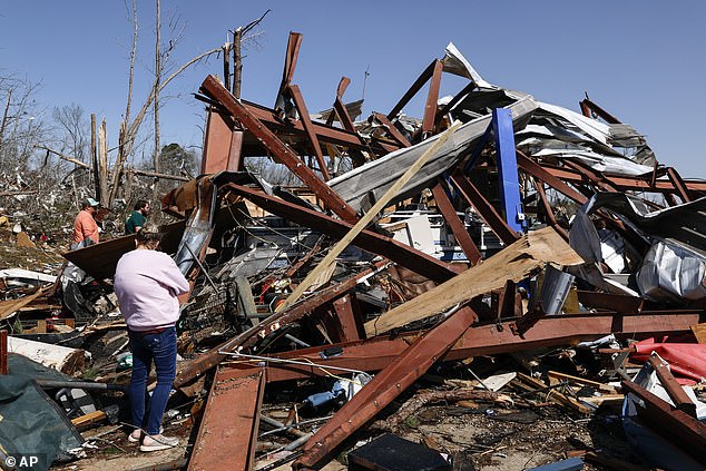
A significant storm system is currently moving through the central U.S., bringing with it an array of hazardous weather conditions including intense thunderstorms, tornadoes, and ice storms. This has resulted in widespread power outages affecting hundreds of thousands of people and placing millions at risk of damage from these destructive forces.
Over 75 million Americans find themselves within the danger area as the enormous weather system moves eastwards, potentially setting off tornado watches, flash flood warnings, and ice storm alerts across several states.
‘A wide area spanning much of the Southeast along with parts of the lower and mid sections will likely experience multiple intense thunderstorms throughout today and into the night.’
Mississippi
Valley into the
Ohio
valleys and the southern Great Lakes region,’
NOAA’s Storm Prediction Center
announced Sunday.
The statement went on to say, ‘There is a high likelihood of extensive areas experiencing damaging winds. Additionally, significant-sized hail and multiple tornadoes are expected from supercell thunderstorms. Some of these tornadoes might be intense.’
About twelve tornadoes might strike cities such as Little Rock.
Arkansas
; Memphis and Nashville in Tennessee; Paducah,
Kentucky
; Evansville and Bloomington,
Indiana
as early as Sunday afternoon and evening.
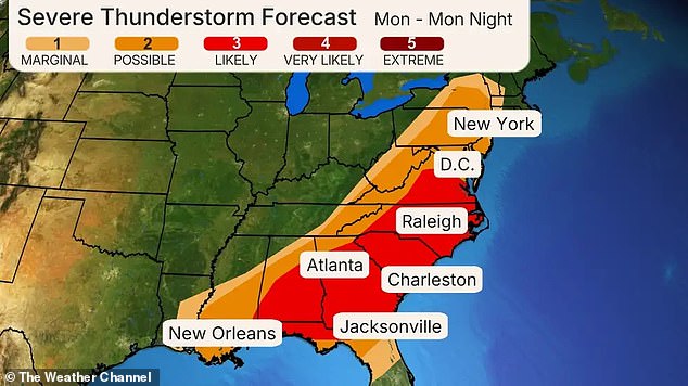
Severe weather forecasted for Monday is anticipated to impact the busy Interstate 81, 85, and 95 routes stretching from New Orleans to Atlanta, Charlotte, and Washington.
DC
, Philadelphia and
New York City
, as reported
Accuweather
.
By late Saturday evening, a tornado warning had been issued for large parts of the region.
Oklahoma
until 1 am Sunday,
ABC News
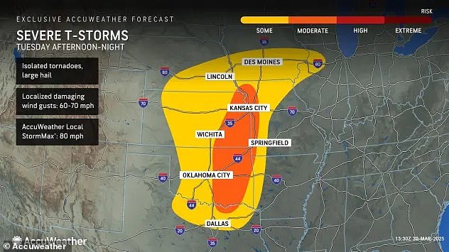
noted, since forecasters cautioned about ‘substantially sized hail along with destructive wind gusts’ throughout the southern Plains region.
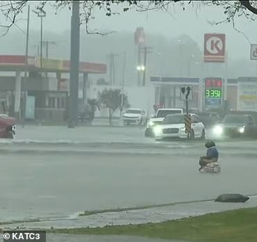
This might affect significant areas such as Oklahoma City and Dallas throughout the evening.
Southern
Louisiana
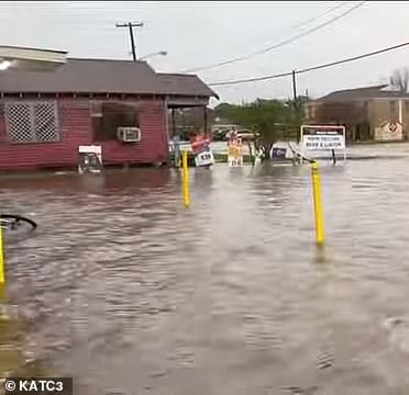
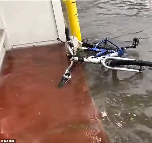
Near Baton Rouge was likewise subject to a flash flood warning, as certain regions had already received up to 4.5 inches of rainfall.
Meteorologists anticipate an additional 1 to 2 inches could occur by early Sunday.
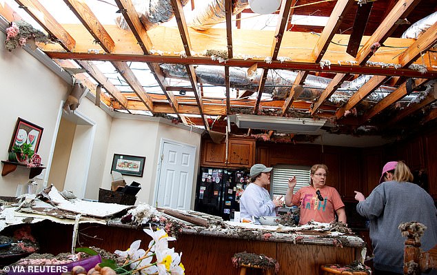
Destruction has already started in sections of the Midwest, with over 200,000 customers experiencing power outages—67,631 in northern Wisconsin and an astounding 148,141 in northern Michigan.
Michigan
– Following a major ice storm that led to extensive tree destruction and complicated travel, according to TMJ4.
Local authorities indicate that several counties in northern Michigan are facing widespread power outages, impacting more than 90 percent of inhabitants, due to trees falling onto electrical wires.
On Sunday, the situation might worsen due to the storm moving eastwards, bringing about several waves of severe weather systems anticipated to move across eastern Texas up to the southern Great Lakes region during the daytime and extending through the nighttime hours.
This is where the highest likelihood of hazardous severe thunderstorms is anticipated.
Meteorologists have likewise alerted about a particularly hazardous area prone to intense tornadoes extending from eastern Arkansas into western regions.
Tennessee
and Kentucky into southwestern Indiana.
It might affect residents in Memphis, Nashville, Louisville, and Evansville.
In addition, thunderstorms accompanied by heavy rainfall are advancing towards the Carolinas and Asheville—areas that have recently experienced wildfires because of arid weather conditions.

On Saturday, seven states ranging from New York to North Carolina continued to face Increased Fire Risk.
Many regions will continue to face significant weather hazards throughout the night.
At the same time, the northern part of the storm is ushering in a cold front, with predictions of snow and ice stretching from North Dakota all the way to New England.
Warnings of an ice storm have been posted for Wisconsin and Michigan, with forecasts indicating that as much as a half-inch of ice could accumulate on roads, trees, and electrical systems.
By Monday, this damaging system will hit the East Coast and the I-95 corridor, possibly affecting zones ranging from Upstate New York to Tallahassee and New Orleans, bringing along hazardous winds and potential twisters in the southern parts.
Read more