by admin | Aug 31, 2025 | greece, hiking, hiking trails, Travel, travel destinations
Curving through the Aegean Sea and rugged hills, the Palia Strata provides an impressive route across the island of Amorgos, located in the Eastern Cyclades. This challenging yet memorable trek allows each step to uncover a landscape that remains wild and unspoiled.
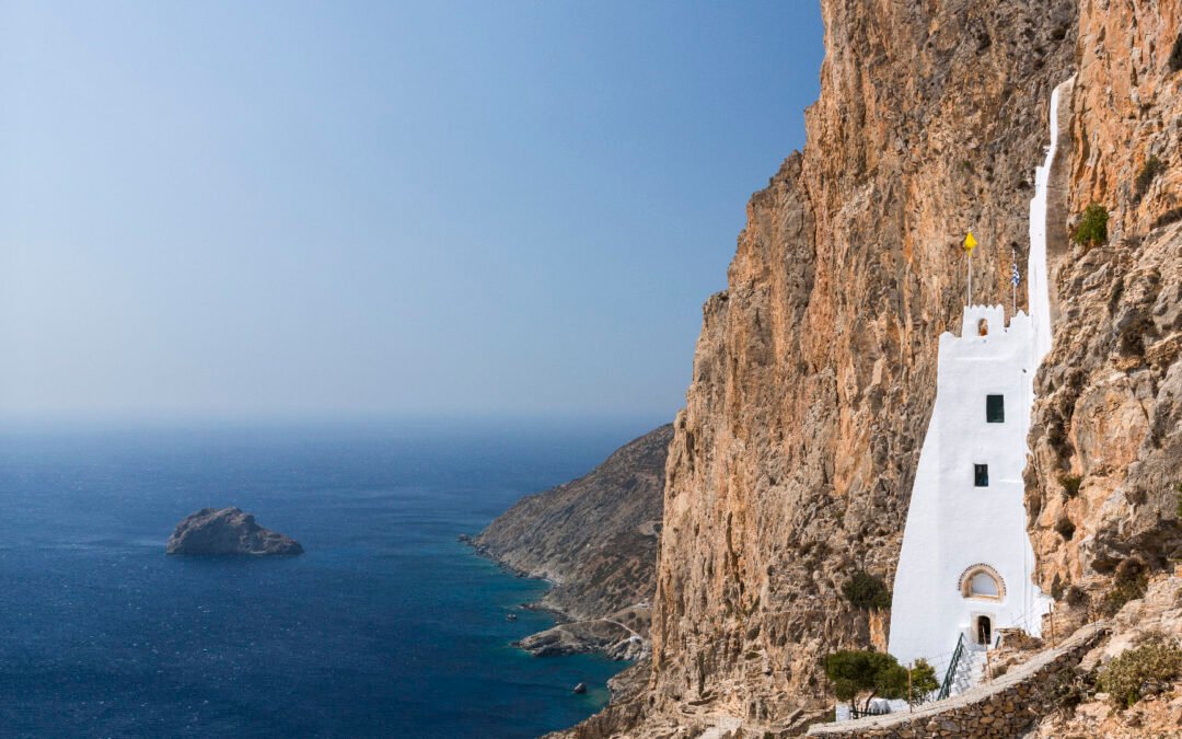
The Palia Strata, a donkey path winding alongside the cliffs
On Amorgós, in the
Cycladic archipelago
The Palia Strata trail connects Chóra with Langada, traversing the island’s dry terrain and fertile hills emerging from the Aegean Sea. This ancient route has been traditionally utilized by shepherds to access remote settlements, running along the crest before slowly descending toward northern communities. Over a distance of 14.5 kilometers, you will travel through a network of dirt trails, terraces, empty highlands, and old agricultural properties. The blend of ocean vistas and interior landscapes turns this into one of the most enchanting hikes available in the Cyclades.
Beginning in Chora, at the center of the Amorgos mountains
The journey begins at Chora, situated 400 meters above sea level, located in the hilly heart of Amorgos. The trail starts from the main road heading toward the coastline, climbing old stone steps. Soon, structures transition into short walls, along with clusters of prickly pears and juniper bushes. From here, the Aegean Sea becomes visible below. The route gradually descends, passing through deserted farming areas and rocky enclosures, alongside some lone chapels, until arriving at a cliff face offering views of the southeastern shoreline.
Chozoviotissa, a monastery situated above the ocean
After two kilometers, the trail arrives at
one of the most remarkable places in Amorgos
The Monastery of Chozoviotissa. Constructed in the 11th century.
th
A monastery perched on a cliffside, accessible through a steep staircase etched into the rock 300 meters above the ocean — the sense of solitude intensifies with each step upward. Within, a slender chapel, several small rooms, and some Byzantine icons bear witness to a continuous spiritual tradition spanning nearly a millennium. From the balcony, the panorama extends over the Aegean Sea, encompassing the islands of Nikouria and Keros to the north.
From Kapsala to Asfondilitis, following the path of Amorgos’ shepherds
Following the monastery, the Palia Strata heads further northeast. The trail ascends across rocky ground and passes the remains of Kapsala, once a high-elevation settlement featuring some ruined sheep pens. You will then arrive at Asfondilitis, an empty village famous for its dry-stone walls and simple carvings. From 1897 until 1943, a lone herdsman named Michalis Roussos chiseled images of women, flower patterns, crosses, and names onto the flat stones along the road.
While descending towards Potamós, a terrace offers a view of the Bay of Aegiali
The path follows the coastal road before easing into a more gradual climb as you near Potamós, a small settlement perched above the Bay of Aegiali. The scenery slowly transforms here, featuring short, neatly maintained stone walls, stepped agricultural areas, and clusters of olive trees. Down below, the harbor of Aegiali and its whitewashed homes create a busier section of the region. Potamós stays a peaceful hamlet, boasting some meticulously renovated buildings, tight stairways, and unbroken vistas across the northern hillsides of the island.
Last part of the coastline approaching the village of Langada
The final part traces the shoreline along a terrace all the way to Langada, located on the northeastern shore of Amorgos. As you follow the incline, you encounter groves and some farmland. The village gradually becomes visible, situated on the hillside and overlooking Mount Krikellos. Charming and famous for its great eateries, Langada maintains its classic design, featuring stone-paved roads, steps, and tiny churches. From the central plaza, you may descend towards the Araklos Gorge or ascend to the walled church of Agía Triáda perched atop a cliff.
Key details to consider before departing
The Palia Strata trail is ideally hiked from April through October, when the weather is most suitable. Plan for an outing lasting anywhere between four and a half to five and a half hours, based on your walking speed and how often you stop. The path isn’t consistently marked, making it advisable to carry a map or utilize a GPS application to ensure you remain on course. During summertime, temperatures along this route can rise rapidly without any shelter or access to water sources. Starting your journey early in the day, preferably before 9 am, helps you escape the peak heat. Wearing appropriate shoes is crucial too, since certain parts of the trail are quite narrow, others are steep, and many areas may be slick because of worn-out stone surfaces.
Amorgós
www.amorgos.gr

by admin | Dec 30, 2024 | adventure travel, hiking, hiking trails, peru, travel destinations
From the historic Inca paths to the snowy peaks of the Andes, Peru offers an abundance of trekking routes. Below is a curated list of some of the finest hikes you can explore during your time in Peru.
The Inca Trail
The
Camino Inca
, the
Inca Trail
Undoubtedly, this 4-day trek ranks among the world’s most iconic hiking routes. Spanning 39 kilometers over four days, the trail winds through captivating archaeological sites and diverse scenery, culminating in an awe-inspiring finish at Machu Picchu via the Sun Gate. Given its challenging nature, participants should be well-prepared with adequate fitness levels and must secure reservations ahead of time due to visitor limitations.
Are you thinking about traveling to Peru? Consider this:
some
pieces to assist you with planning
out
your trip:
-
Explore Peru’s loveliest towns
-
What is the ideal time of year to visit Peru?
-
In Peru, archaeologists have uncovered a 3,000-year-old burial site.
-
In Peru, archaeologists have discovered a temple belonging to a pre-Inca culture.
The Salkantay Trek
If you want to steer clear of large groups, the Salkantay Trek is an excellent choice. Spanning 4-5 days, this hike offers breathtaking views of various terrains such as the awe-inspiring Salkantay Pass standing tall at 4,615 meters, verdant valleys, and dense jungles. Although notably tougher than the Inca Trail, this route provides a rewarding adventure off the beaten path.
ends at Machu Picchu
for an unforgettable journey away from well-trodden paths.
The Santa Cruz Trek
Close to the town of Huaraz lies the Santa Cruz Trek, which is essential for avid hikers seeking mountains. Spanning 3 or 4 days, travelers will have the opportunity to witness breathtaking views of the Cordillera Blanca, a striking mountain chain within the Andes featuring snowy summits and glacier-fed lakes. Ideal for those looking to delve into elevated alpine terrain, this moderately challenging hike covers more than 50 kilometers.
Choquequirao
While not as well-known as Machu Picchu, Choquequirao stands as another Incan settlement tucked into the Andean mountains. The journey here spans 3 to 5 days and presents substantial difficulty due to considerable shifts in altitude. However, finishing this challenging hike rewards you with breathtaking vistas of steep ravines and remote archaeological sites. Unlike more popular routes, this lesser-traveled path provides an exclusive adventure far removed from typical tourist traffic.
The Ausangate Trek
For the more experienced among you, the Ausangate Trek is a demanding 5-7 day adventure around Mount Ausangate (6,384 m), one of Peru’s highest peaks at a very high altitude. This trek takes you through a wide variety of landscapes, including colourful lakes, imposing glaciers and the famous Mountain of Seven Colours (Vinicunca).
The Colca Canyon
The Colca Canyon, which ranks among the deepest gorges globally at approximately 3,400 meters, offers a remarkable 2 to 3-day hiking experience that blends breathtaking landscapes with rich cultural encounters. As you traverse this route, you have the opportunity to observe majestic condors soaring overhead and explore quaint traditional communities scattered throughout the region.
The editor’s advice
Hiking in Peru poses significant challenges, and adequate preparation is essential before setting off. Below are some useful suggestions to assist you in planning your journey effectively:
-
The ideal period for hiking in Peru is from May to September, coinciding with the dry season.
-
Adapting to the high elevation can pose a difficulty, so make sure to stay at your location for several days prior to starting your journey.
-
Ultimately, anticipate significant fluctuations in temperature.
-
Pack suitable attire along with a reliable backpack.
by admin | Aug 28, 2024 | beautiful places, hiking, hiking trails, mountains, travel destinations
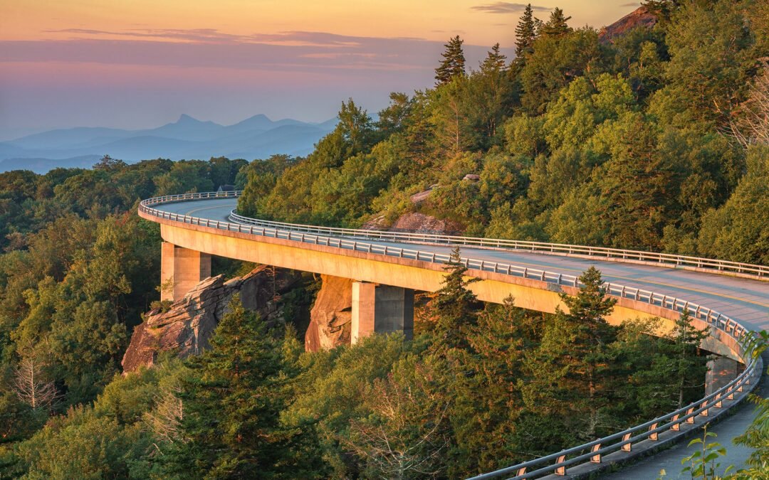
In the depths of the Appalachian Mountains, located in the southeastern part of the United States, lies the Blue Ridge Parkway, which extends over 750 kilometers against the breathtaking backdrop of hills and woods. Join me as we embark on an exploratory adventure!
The Blue Ridge Parkway, a legendary path amidst the heavens, woods, and mountain ranges.
The Blue Ridge Parkway derives its name from the Blue Ridge Mountains that run through it, earning their appellation due to both their blue-hued appearance and the distant greenish tinge of the surrounding forests. Spanning more than 750 kilometers, this scenic drive was crafted with the purpose of providing an immersive experience into nature’s splendor. It connects various attractions including the Great Smoky Mountains National Park situated nearby.
North Carolina
and Tennessee, to Shenandoah National Park in Virginia.
Constructing the roadway spanned nearly fifty years, culminating in an extraordinary feat of environmental engineering. The path winds intricately along cliffsides or soars across streams via majestic bridges, offering breathtaking vistas of rolling hills, dense woodlands, and towering summits at every bend. Its uniqueness lies in how it transforms with each passing season. During winter, frosty blankets and early fog lend a magical allure. Spring breathes life into the slopes through vibrant blooms of wildflowers, azaleas, and rhododendrons. Summer turns the woods into refreshing retreats perfect for leisurely hikes. However, autumn stands out as arguably the parkway’s peak moment; the leaves ignite into vivid hues—reds, oranges, and yellows—that draw countless tourists eager to witness nature’s grand display.
A captivating encounter with the surrounding natural environment, traditions, and past.
The Blue Ridge Parkway offers an idyllic setting for hikers with over 185 miles of trails that vary from easy walks to strenuous hikes. Nestled among mountains and woodlands, this area allows visitors to discover famous landmarks like Mount Mitchell, which stands as the tallest mountain east of the Mississippi River, or Linville Gorge, often referred to as the “Grand Canyon of the East.” Additionally, numerous rivers and lakes provide opportunities for activities such as fishing, canoeing, and kayaking.
However, the Blue Ridge Parkway offers a chance to delve into the area’s deep cultural heritage and historical background. Situated close to the Blue Ridge Parkway,
Asheville, North Carolina
, is an absolute must-visit. Known for its bohemian vibe, this town overflowswith art galleries, artisanal shops, and well-known eateries. Asheville also gained prominence for the
Biltmore Estate
, the largest private home in the United States, which offers fascinating insights into the wealth of the Vanderbilt family in the late 19
th
century.
Another must-see attraction is the Moses H. Cone Memorial Park, which exemplifies Colonial Revival style. This magnificent estate was constructed early in the 20th century.
th
In this century, the property features meticulously maintained gardens and offers, from the mansion’s terrace, stunning vistas of the Blue Ridge Mountains. Additionally, in Virginia stands the Mabry Mill, an impeccably preserved watermill that has become iconic within the area. This location allows visitors to observe demonstrations of corn grinding as well as the creation of traditional implements, providing insight into historical craftsmanship methods.
by admin | Aug 26, 2024 | europe, hiking, hiking trails, Travel, travel destinations
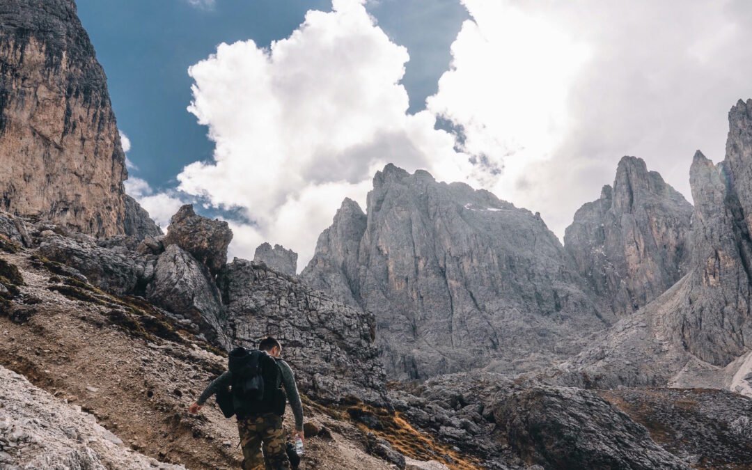
Do you constantly search for unexplored paths, wondering which trail offers the most breathtaking views in Europe? If so, let’s venture into Italy where beauty awaits.
Italy is consistently an excellent travel destination, particularly when seeking spectacular hiking routes. In our opinion, the most breathtaking hiking trail in Europe is located in Italy, notably within the stunning
Dolomites mountain range
a UNESCO World Heritage Site renowned for its outstanding natural splendor and significant geological value.
Do you fancy visiting the Dolomites?
Below are several pieces that can assist you in organizing your journey.
:
-
A flawless 6-day plan for exploring the Dolomites via road trip
-
The loveliest location in the Dolomites, a tranquil refuge high among the peaks.
-
The Dolomites now feature an amazing new 7-day trekking route that has recently opened.
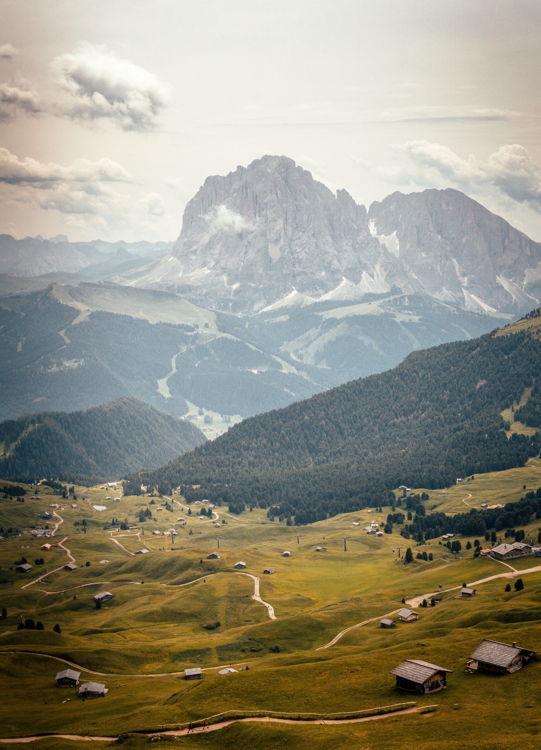
Situated in northern Italy, the striking
Dolomites mountain range
serves as the location for a famous hiking path,
the Alta Via 1
It is a treat for seasoned hikers, offering breathtakingly stunning views everywhere you look.
Covering a
approximately 120 kilometers in total
The complete journey can typically be finished within 10 to 15 days based on your walking speed and how many stops you decide to take. However, if you’re short on time, you may opt to cover just specific segments of the trail instead of completing the whole path.
The Alta Via 1 is a
moderately difficult
Hiking here can be challenging due to certain areas being quite technical, featuring stretches alongside ridgelines or cables similar to a via ferrata experience. The elevation during this trek fluctuates from approximately 1,500 meters up to 2,750 meters, including significant ascents and descents throughout the route.
The Alta Via 1, an extraordinary trek through breathtaking landscapes
Clearly, this is among the primary factors that make the Alta Via 1 one of Europe’s most stunning treks: the remarkable diversity of scenery encountered throughout the journey ensures that you’ll be reaching for your phone or camera repeatedly.
From iconic summits like the Tre Cime di Lavaredo, Monte Pelmo, and La Civetta, to vibrant alpine meadows bursting with flowers and sprawling coniferous woodlands… there’s a wealth of attractions waiting for your discovery! Coupled with awe-inspiring vistas at every turn and spontaneous meetings with chamois and marmots, this makes for an utterly remarkable trek.
What path should you choose for the Alta Via 1 trek?
The entire Alta Via 1 trek begins at Lake Braies, often referred to as Pragser Wildsee—a stunning turquoise alpine lake in South Tyrol—and concludes in Belluno, a municipality located in the southern part of the Dolomites. Along this path, you will traverse multiple mountain huts; be sure to reserve your spot during peak times! The length of each day’s section ranges from approximately 6 to 15 kilometers.
Below are the most striking portions of the Alta Via 1:
-
From
Braies
L
ake to Fanes
H
ut:
18 kilometers featuring an 800-meter incline and a 500-meter decline, providing an enchanting journey through the untamed splendor of the Dolomites with expansive vistas available from the very beginning.
-
From
Lagazuoi
H
ut to Nuvolau
H
ut:
Approximately 12 kilometers long with an elevation gain of 600 meters and a drop of 800 meters, this route offers vistas of the Tofane massif. Conclude your trek at the peak for panoramic 360-degree views. Make sure not to miss witnessing the sunset!
-
From Giau Pass
to Città di Fiume
Hu
t:
approximately 10 kilometers with a descent of 500 meters and an ascent of 300 meters, featuring one of the most renowned routes in the Dolomites, the Giau Pass. This path winds through meadows and offers views of Monte Pelmo, which is often referred to as “God’s throne.”
-
From
Vazzoler
Hut
to Tissi
H
ut:
Covering approximately 7 kilometers with a total ascent of 600 meters, this route steadily climbs through thick forests and Alpine pastures up to the Tissi Hut, which sits high above Lake Alleghe. One of the highlights is the breathtaking vista of the iconic Civetta peak in the Dolomites, especially stunning during dawn or dusk.

by admin | Aug 22, 2024 | beaches, hiking, hiking trails, outdoor activities, walking
This tranquil trek through the untamed charm of Cap Ferrat includes stony shores and jagged bays.
Just a twelve kilometers distance away
Old Nice
Wandering along the Cap Ferrat coastal trail provides an excellent opportunity to reconnect with nature and enjoy spectacular vistas. Spanning almost the complete length of the Saint-Jean-Cap-Ferrat peninsula, this route stands out as one of the prime natural attractions on the French Riviera. Stretching for approximately 14 kilometers, it is suitable for everyone and presents magnificent sights of the Mediterranean Sea, the harbor at Villefranche-sur-Mer, and the Cap.
Nice
.
Starting from Lido, the path to the Saint-Jean-Cap-Ferrat harbor takes you through an array of scenery including hidden shingle shores, dramatic cliff faces, covert bays, and sprawling pine woods. Along this route, numerous breathtaking vistas await your discovery. Nature enthusiasts will appreciate the educational markers detailing regional flora and fauna alongside historical insights about the area. Additionally, you’ll have the chance to spot opulent mansions perched high above the coast.
Chemin des Douaniers
06230 Saint-Jean-Cap-Ferrat
Saint-Jean-Cap-Ferrat