by admin | Aug 13, 2025 | beautiful places, outdoor activities, tourist attractions, Travel, travel destinations
The New England area boasts stunning parks and scenic natural attractions. Starting from the impressive White Mountains to the wild shores of Cape Cod, these are some of the lesser-known treasures found in this part of the northeastern United States.
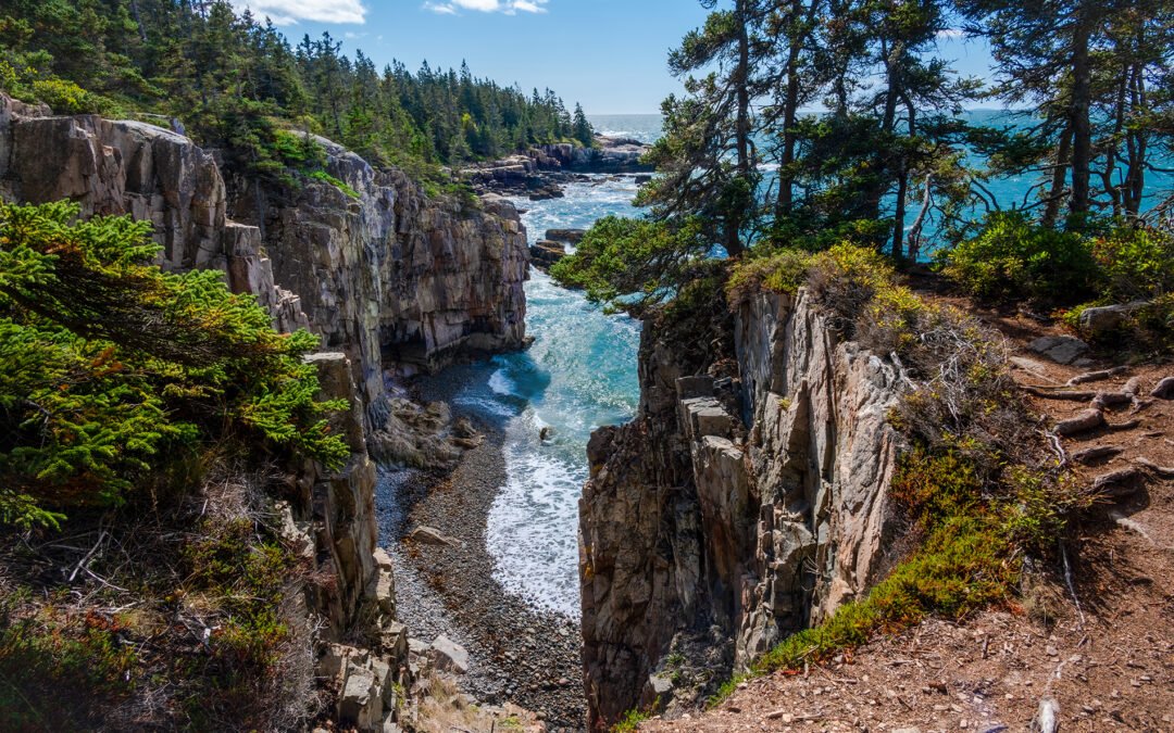
Acadia National Park, the gem of the Maine coastline
Three hours away from Portland, located in the state of Maine,
Acadia National Park
It is a remarkable lush area along the Atlantic coastline. Situated on Mount Desert Island, which was created 550 million years ago, this park presents a distinctive combination of hills, woodlands, sandy shores, and rugged seashores. We suggest ascending Mount Cadillac early in the day to experience one of the finest sunrises in New England, and then relax at Sand Beach and Echo Lake during the night. Truly unforgettable!
The White Mountains National Forest, considered the gem of New Hampshire
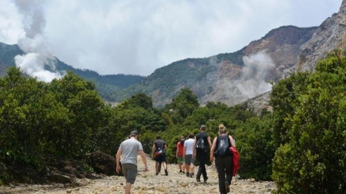
The White Mountains in New Hampshire feature one of the most remarkable natural attractions in New England: the White Mountains National Forest, known for its rugged summits, large forest areas, numerous streams, and powerful rivers. Popular activities include walking along the Appalachian Trail, scaling Mount Washington, and discovering beautiful canyons like Rocky Gorge. During the colder months, the area transforms into an ideal destination for those who enjoy winter sports, offering both downhill and cross-country skiing paths.
The Mohawk Trail State Forest, the gem of western Massachusetts
Located in western
Massachusetts
The Mohawk Trail State Forest derives its name from an old Native American trading path that passes through the area. Today, this green forest is famous for its beautiful roadsides, meandering streams, and towering rock faces. The park provides numerous chances for recreational pursuits like pitching tents, angling, and paddling canoes. Though not widely recognized, it’s definitely deserving of a trip!
Baxter State Park, home to the Katahdin Mountains
Baxter State Park, found in Maine, is another earthly paradise for hikers and outdoor enthusiasts. Mount Katahdin, the state’s highest peak, rises above the park. The name means “Great Mountain” in the local Penobscot language. This park is criss-crossed by a skein of hiking trails, threading through a wild territory full of elk, fallow deer, bears and other forest animals. The sights from the slopes of Mount Katahdin are breathtaking, with uninterrupted views of the surrounding lakes, forests and mountains. In autumn, the colours of the maple leaves turn the whole landscape into a dash of fiery paint.
Franconia Notch State Park, the other one
gem
of the White Mountains
Nestled within the White Mountains of New Hampshire, just beside the White Mountains National Forest, lies Franconia Notch State Park. Though more compact than its larger neighbor, this park hosts some of the area’s most famous attractions, including Franconia Basin, Flume Gorge, and the Sentinel Pine Covered Bridge. Adventure seekers can hike up nearby summits like Mount Lafayette to enjoy breathtaking vistas of the park.
Cape Cod Coastal Park, an extraordinary seaside treasure in Massachusetts
On the
coast of Massachusetts
Cape Cod National Seashore is well-known for its sandy shores, sand dunes, pine forests, and stunning seaside landscapes. Cycling paths like the Cape Cod Rail Trail provide an excellent opportunity to experience the region by bicycle, whereas walking trails present breathtaking vistas of the Atlantic Ocean. The seashore is also renowned among bird enthusiasts. It hosts approximately 350 documented species, making it home to one of the most extensive collections of coastal birds in America.
The Green Mountain National Forest, a gem of Vermont
The Green Mountain National Forest in Vermont is an essential visit for nature lovers. Spanning nearly 1,200 square kilometers, this area provides numerous activities throughout the year, including canoeing, angling, and Nordic skiing. Trekking paths like the Long Trail, which stretches across the entire forest, lead visitors through different terrains ranging from rocky summits to vibrant green basins. During fall, very few spots in New England match its beauty!

by admin | Apr 3, 2025 | lakes, national parks, outdoor activities, recreation and leisure activities, tourist attractions
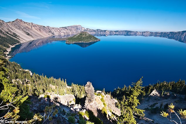
The United States’ deepest lake will be off-limits to tourists until 2027 due to scheduled maintenance, leaving just a brief period during which one can swim there.
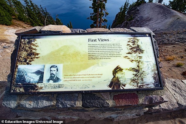
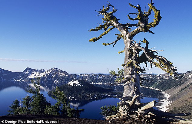
Crater Lake National Park in
Oregon
draws over 500,000 visitors annually, thanks to the stunning 592-meter-deep lake which serves as the centerpiece of this beautiful setting.
Day trippers can enjoy diving from a nearby 11-meter cliff face into the clear blue depths of the waterway, which sits in the blown-out caldera of a once mighty volcano known as Mount Mazama.
Encircled by the Cascade Mountains, the pristine blue waters of the lake feature two notable landforms — Wizard Island and the Phantom Ship natural rock formation — both of which are accessible for exploration.
The extensive lagoon serves as a habitat for substantial populations of kokanee salmon and rainbow trout, making it an ideal location for anglers and those who enjoy water activities like boating.
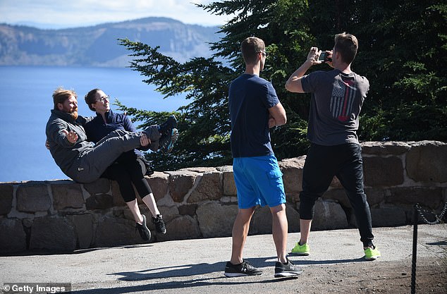
Throughout the years, millions of individuals have traversed the narrow Cleetwood Cove Trail, a brief but steep pathway serving as the sole access to the coast.
But starting this summer, the trail will be closed for two years for rehabilitation works, the National Park Service has announced.
The NPS stated in a release that this initiative aims to restore the trail along with its associated facilities to guarantee secure passage to the lake, deliver essential amenities for visitors, and safeguard the natural surroundings.
The project encompasses the complete refurbishment of the 1.1-mile long Cleetwood Cove Trail, which includes enhancements to the trail surface and retaining structures.
The NPS teams will similarly pinpoint hazardous areas prone to rockfall and make necessary adjustments in those locations.
This huge undertaking also includes demolishing the decaying pier and substituting it with a ‘sturdily constructed marina.’
The NPS teams mentioned that they will replace the small, outdated restroom facility near the marina with bigger, more contemporary ones.
The aim of this project is to avoid any incidents occurring at the lake. Back in 2019, a 28-year-old man from Florida was involved in an accident.
stumbled and dropped 245 meters into the water
.
Tyler Johns, a welder hailing from Bronson, amazingly managed to survive after slipping during a hike.
‘We went to Crater Lake to sight-see and I propped down on a snow bank that I thought was soft,’ Johns told SANGGRALOKAat the time.
‘I somewhat dove into what I thought was a soft snowbank but ended up bouncing off it before starting to slide downhill backwards and headfirst.’
‘I skidded for about 800 feet, did a spin, came to a halt, and ended up with some bumps on my head, a cut on my arm, and bruised ribs.’
John said he felt achy all over and beaten up, plus his boots were filling up with snow.
He attempted to ascend again, yet failed to reach the summit as the cliff face turned too steep to overcome.
‘I began climbing back up, 150 feet upward, but I couldn’t go any further as there weren’t any trees or anything to hold onto,’ he shared with SANGGRALOKA.
Following approximately seven hours of searching, rescuers located John and transported him to safety via helicopter.
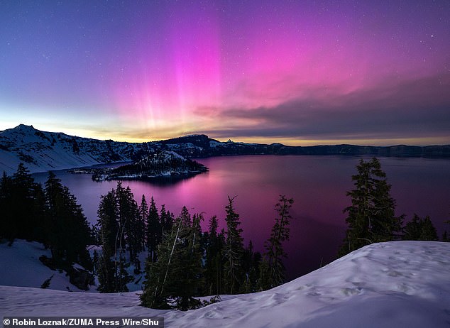
On calmer trips to the lake, fortunate visitors have had the chance to see the aurora borealis, commonly referred to as the northern lights, illuminating the water body.
In May 2024, a natural spectacle illuminated the region with a soft pink hue above the water and nearby mountains, offering breathtaking vistas during a uncommon event in this location.
The NPS stated in a release that the park intends to commence construction in 2026 as part of the rehabilitation initiative.
‘Owing to the volume of work needed and the brief construction periods, trail closures will be necessary and are anticipated throughout the 2027 and 2028 summer seasons.’
‘In this period, boat tours won’t be offered, and the trail will remain closed because of construction activities and risks from rockfalls.’
‘Provided the construction proceeds according to plan, the refurbished trail should be reopened during the summer of 2029.’
Read more
by admin | Mar 20, 2025 | asia, outdoor activities, Travel, travel destinations
![]()
Lifehack My ID
– Apakah Anda berencana untuk menghabiskan cuti di Garut sebentar lagi?
Dari Jakarta, Anda dapat menggunakan kendaraan pribadi untuk pergi ke Garut dan perkiranya membutuhkan waktu sekitar 5 jam untuk melakukan perjalanan tersebut.
Berlibur ke Garut memungkinkanmu menikmati waktu sekitar 3 hari 2 malam.
Dalam waktu 3 hari 2 malam, perjalanan ke Garut dapat mencakup berbagai destinasi pariwisata.
Rencana Perjalanan Mendaki Gunung Papandayan Dari Pusat Kota Garut, Sediakan Anggaran Sekitar Rp 110 Ribu
Pastikan pula untuk menikmati aneka hidangan khas Garut yang memanjakan lidah.
Berikut
Lifehack My ID
Telah menyusun rincian perjalanan wisata di Garut untuk 3 hari 2 malam, berasal dari Jakarta dan menggunakan kendaraan pribadi.
LIHAT JUGA:
Rencana Perjalanan Garut 3 Hari 2 Malam Mulai Dari Jakarta
Hari Pertama: Penjelajahan Alam dan Kuliner di Garut
07.00
– Keberangan dimulai dari Jakarta menuju Garut
-
Dari Jakarta dengan kendaraan bermotor membutuhkan waktu sekitar 4 sampai 5 jam untuk perjalanannya.
11.00
– Sarapan di Warung Makan Pak Asep Strawberry
-
Menu andalan: nasi liwet, gurame goreng, ayam kampung bakar
-
Atmosfer di saungan bambu yang menghadap ke persawahan
5 Penginapan Hemat di Garut Jawa Barat yang Menyediakan Fasilitas Komplit Harga Dimulai dari Rp 100 Ribu
13.00 –
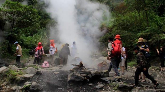
Pengunjungan Ke Wisata Alam Kawah Kamojang
-
Mengagumi kawah belerang bersama panorama awan ringan
-
Anda bisa merasakan sauna alami dengan menggunakan uap dari kawah.
-
Tiket masuk Rp 35.000
15.30
– Menikmati kehangatan sumber mata air panas di Garut
-
Pengendapan diri di sumber mata air hangat yang natural
-
Opsi lokasi: Taman Air Sabda Alam, Pegunungan Darajat, atau Cipanas Indah
-
Harga tiket masuk dimulai dariRp 30.000

16.30
– Check-in penginapan
-
Vila Sumber Alam, sebuah tempat tinggal ala Sunda yang menawarkan panorama pegunungan (dengan tarif permalam dimulai dari Rp 373.464).
-
Resort Sumber Alam menawarkan pengalaman berada di tengah alam dengan bungalow yang terletak di atas air (harga dari Rp 410.000 per malam).
-
Hotel dan Resor Tirtagangga berada di dekat Pemandian Air Panas Cipanas (dengan tarif yang dimulai dari Rp 526.500 per malam).
18.00
– Makan malam di Restoran Setia Kawan
-
Pilihan hidangan unggulan: Nasi timbel, Sayuran Asam, Empal Gepuk
19.30
– Kembali ke tempat menginap dan beristirahat
Sajikan Spot Selfie dan Berbagai Macam wahana Menyenangkan, Datangi Kamojang Ecopark di Samarang, Garut, Jabar
Hari Kedua: Ekspedisi Gunung & Warisan Budaya Garut
06.30
– Makan pagi dan persiapan menuju Gunung Papandayan
-
Makan pagi di hotel ataupun mencicipi Bubur Ayam Pak Oman
-
Perjalanan menuju Gunung Papandayan membutuhkan waktu sekitar 1,5 jam.
08.00
– Mendaki santai ke Gunung Papandayan
-
Mengagumi panorama Hutan Mati, Kawah Papandayan, serta Tegal Alun (hamparan edelweiss)
-
Ideal bagi pemula, dapat melakukan trekking ringan selama sekitar 2 jam.
-
Tiket masuk Rp 20.000
Booking kamar di hotel Garut
12.00
– Sarapan di Warung Makan Kampung Muara Sunda
-
Pilihan masakan unggulan: Ikan bakar, karedok, sup ular tanduk
13.30
– Kunjungan wisata ke Kampung Adat Pulo (Situ Cangkuang)
-
Melihat Candi Cangkuang, yang merupakan candi Hindu unik di Jawa Barat
-
Mengelilingi danau menggunakan perahu tradisional
-
Tiket masuk Rp 10.000
16.00
– Wisata belanja
-
Membeli dodol Garut dari Dodol Picnic atau Chocodot (Dodol Coklat)
-
Melakukan pencarian untuk jaket kulit autentik di Sukaregang Leather Center
-
Bujet Rp 100.000
18.30
– Makan malam di Restoran Sambal Hijau
-
Pilihan utama: ayam kampung goreng sambal dadakan & sayuran mentah fresh
20.00
– Kembali ke tempat menginap dan beristirahat
Perjalanan gunung untuk Gunung Papandayan dengan harga sekitar Rp 300 ribu.
Hari ketiga: Ekspedisi Air Terjun dan Makanan Penut-up
07.00
– Makan pagi dan keluar dari tempat menginap
08.00
– Mengunjungi Curug Orok
-
Terjunan air yang menawarkan atmosfer natural dan segar
-
Tiket masuk Rp 17.000
10.00
– Menyukai secangkir kopi di Kopi Luwak Cikuray
-
Kopi autentik Garut bersama pemandangan perkebunan kopinya

12.00
– Sarapan di Sate Maranggi Pak Nur
-
Utama menu: Sate Maranggi khas dari Garut
13.30
– Membeli buah tangan di Pasar Ceplak
-
Sajian oleh-oleh lokal: dorokdok (kraker kulit), opak, burayot
-
Bujet Rp 100.000
15.00
– Perjalanan pulang
-
Perjalanan kembali ke Jakarta
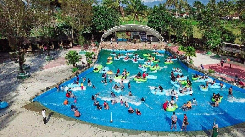
Diskon harga karcis untuk bermain di Tropikana Waterpark Garut
Perkiraan Biaya Perjalanan Ke Garut Selama 3 Hari 2 Malam Dari Jakarta:
Hari ke-1
|
Hari ke-2
|
Hari ke-3
|
Tiket wisata
|
Rp 65.000
|
Rp 30.000
|
Rp 17.000
|
Makan
|
Rp 100.000
|
Rp 150.000
|
Rp 100.000
|
BBM
|
Rp 200.000
|
–
|
Rp 200.000
|
Hotel
|
Rp 373.464
|
Rp 373.464
|
–
|
Oleh-oleh
|
–
|
Rp 100.000
|
Rp 100.000
|
TOTAL
|
Rp 738.464
|
Rp 653.464
|
Rp 417.000
|
Bila dikalkulasikan totalnya, perkiraan biaya berlibur ke Garut selama 3 hari 2 malam dari Jakarta adalah sebesarRp 1.808.928.
(Lifehack My ID/SA)

by admin | Aug 22, 2024 | beaches, hiking, hiking trails, outdoor activities, walking
This tranquil trek through the untamed charm of Cap Ferrat includes stony shores and jagged bays.
Just a twelve kilometers distance away
Old Nice
Wandering along the Cap Ferrat coastal trail provides an excellent opportunity to reconnect with nature and enjoy spectacular vistas. Spanning almost the complete length of the Saint-Jean-Cap-Ferrat peninsula, this route stands out as one of the prime natural attractions on the French Riviera. Stretching for approximately 14 kilometers, it is suitable for everyone and presents magnificent sights of the Mediterranean Sea, the harbor at Villefranche-sur-Mer, and the Cap.
Nice
.
Starting from Lido, the path to the Saint-Jean-Cap-Ferrat harbor takes you through an array of scenery including hidden shingle shores, dramatic cliff faces, covert bays, and sprawling pine woods. Along this route, numerous breathtaking vistas await your discovery. Nature enthusiasts will appreciate the educational markers detailing regional flora and fauna alongside historical insights about the area. Additionally, you’ll have the chance to spot opulent mansions perched high above the coast.
Chemin des Douaniers
06230 Saint-Jean-Cap-Ferrat
Saint-Jean-Cap-Ferrat
by admin | Jun 26, 2024 | hiking, islands, outdoor activities, tourist attractions, Travel

There’s a magical pond located in
Ballaglass Glen
Carved deeply into the old flagstones, surrounded by oak, larch, and beech trees, it’s nourished by a waterfall, sparkling with beams of light, and likely conceals something secretive.
mooinjer
veggey
– Manx Gaelic term for the mythical “little people.” As I slipped my weary legs into the freezing-cold water, I experienced a surge of excitement.
It was the most splendid day as I took on my first of the island’s eight newly developed areas.
summit walks
; Among these medium-to-challenging routes, 25 out of the Isle of Man’s 300-metre-plus peaks have been conquered. Despite its modest size—only stretching 33 miles long and 13 miles wide at its furthest extents—the island boasts ample rough landscapes and rewarding ascents.
According to Kate Bergquist, who serves as a walking ambassador for the Isle of Man and founded Soul Adventures, there lies unexplored adventure. She assisted in organizing these summit hikes with the aim to lure trekkers away from coastal paths, demonstrating that the island offers much more than just leisurely tours and seaside strolls. “The highlands present quite a contrast,” she explains to me. “From here, you can enjoy expansive vistas encompassing all seven realms: England, Ireland, Scotland, Wales, Mann, Sky, and Sea.”
I had boarded a ferry from Liverpool to the island with the aim of proving that I, as a woman, could conquer Man without using a car within just three days. On the first day, during my journey, I encountered Kate onboard the ferry.
Snaefell Mountain Railway
— which has been cheerfully ascending to the island’s 620-meter peak since 1895 — was a success. The wind was persistent, yet the sky remained clear and blue as we departed from the train tourists heading into the seven-mile stretch.
northeastern summit five-peak challenge
Route. “She’s quite ripe,” Kate smiled.
We looked at all of it: the smooth northern plains, the canyon-scarred south, the deep green waves of the Irish Sea, and the far-off Lake District.
We were tracking along an unoccupied, wave-like crest, heading towards a pointed destination.
North Barrule
— At 565 meters, this is the island’s second-highest summit. During our walk, we discussed various topics ranging from the reintroduction of Manx-language place names on maps to the Moddey Dhoo, a legendary black dog believed to haunt the area. We enjoyed some food as well.
Manx
bonnag
, the tastiest spiced soda bread. We looked out at every view: the vast expanse of the north plains, the canyon-scarred south, the dark waves of the Irish Sea, and the far-off Lake District.
Kate is enthusiastic about how spending time in natural settings can positively impact mental well-being. “Nobody has ever felt worse after taking a stroll in the woods,” she stated confidently as we made our way down through the ferns towards Ballaglass. “Cold water—there’s nothing more potent.”
I definitely felt great after the entire adventure, which concluded with me giving Cornaa, an unofficial stopping point close to the glen, a thumbs-up before cheerfully returning to Douglas via the island’s electric train.
My schedule for day two involved covering a portion of the 10-mile route.
central east summits
The route begins with a brief taxi journey from Douglas. However, our attempt started poorly as my driver overlooked the trailhead—an unsettlingly named spot.
Windy Corner
— Due to the heavy rainfall and clouds obscuring the highland characteristics. He turned around, and I ventured out into a demoralizing thick fog. Questioning my choice, I set off across an expansive, pathless moor, sinking knee-deep into damp tufts of grass.
As the clouds briefly parted, I noticed ravines extending to one side. Trusting my OS map, mobile app, and perhaps some divine intervention, I reached a wooden gate set within a stone fence. A short stretch of charming forest lifted my spirits momentarily before I carried on, quickly merging onto an expansive, well-defined path. However, the ground beneath me remained rough and jagged, with rain pouring heavily, pushing the boundaries of what could be considered mildly enjoyable activity. Upon reaching the 546-meter-high Beinn-y-Phott—though I couldn’t spot it—I opted out, heading towards the mountain road where I had to dodge wet patches and vehicles until arriving at Bungalow station drenched and disheartened. From there, thoroughly soaked and beaten, I boarded the mountain train back down to Laxey.
Kate mentioned to me that out of the eight hikes, her favorite was the 12-mile one.
southwestern peaks and Niarbyl coastline
path, which I had dismissed due to its difficult accessibility. However, coincidentally, this route turned out to be available.
bus
from Douglas to tiny
Niarbyl
The following day, I figured I might as well take a slight detour and include some coastal paths to get to the small seaside town of Port Erin, which would make the journey about 15 miles long; assuming everything went smoothly, I’d return to Douglas via the historic 150-year-old steam railway, feeling quite victorious. When I asked for Kate’s opinion, she responded with, “Epic plan.”
On Saturday morning, with the sunlight beaming down, I got on a bus traveling around the island. There was just one more traveler who mentioned his intention of hiking at Niarbyl too. He went on to share details about the yearly Parish Walk—a grueling 85-mile race covering every church on the island, which has been happening every June since the mid-19th century. It turned out he had triumphed in this event before. We reached our stop by the ocean where the road ended, exchanged good wishes, and then he quickly drove away. Taking my own sweet time, I proceeded onward.
Kate was right. The path we took was spectacular. Initially, I went north via the roadway, then passed through fragrant gorse and bracken. At the point where Glen Maye’s mouth joined the shore, I continued along the valley as it wound inward; lush, babbling, narrow, and twisty, ending with a hidden cascade plunging down—a scene even more enchanting than Ballaglass. Further ahead,
Glen Maye
I followed a path next to a narrow stream, with the sunlight shimmering on the water stained reddish-brown and catching the rainbow-like wings of damselflies.
The Hill of the Day Watch is where locals used to keep an eye out for Viking raiders.
The climb up to the 483-meter-high South Barrule was brief but challenging, forming an out-and-back route. Eager to complete it after tackling its northern counterpart, I set forth. South Barrule served as a Celtic Iron Age hillfort; archaeological digs revealed numerous remnants of roundhouses within its bounds. On sunny days, the expansive view from atop makes evident why this location held significant tactical importance.
I went downhill and soon after started climbing up another hill to reach the 437-meter-high Cronk ny Arrey Laa (Hill of the Day Watch). This place used to be where locals watched for Viking ships. Nowadays, it’s great for observing nesting birds and enjoying panoramic views of the rugged western coastline. The trail was supposed to head north toward Niarbyl from there. However, I decided to go my own way and turned south with the aim of reaching Port Erin and taking in more scenery along the way.
Raad ny Foillan
the route that circles along the shoreline of the island.
It wasn’t easy. The southwestern part of the Isle of Man boasts the island’s tallest and rockiest shores—steep, dramatic, and awe-inspiring. I struggled through thick vegetation and hauled myself uphill, feeling my calves strain. Yet when I looked up, I saw a shimmering expanse of silvery water stretching as far as Ireland;rabbits darting about and seagulls circling overhead;cliffs rising sharply, slanting, plunging, and climbing skyward.
Ultimately, the 19th-century battlements of
Milner’s Tower
famous for Port Erin Bay. After about another mile, I reached the town’s crescent-shaped sandy shore, sipping a chilled beer from the beach bar.
I examined the destruction: broken branches, hair tousled by the wind, an uncertain smell. Yet, still alive — and humming with activity.
The journey was supplied by
visitisleofman.com
.
Mannin Hotel
In Douglas, the B&B offers double rooms starting from
£105pn
.
Soul Adventures
arranges escorted tours, outdoor swimming, and various other activities.
Liverpool-Douglas
foot-passenger returns from £
52 pp. Ferries also operate from Heysham and Belfast.