
by admin | Aug 15, 2025 | beautiful places, nature, tourist attractions, travel destinations, world
Located in northwest England, nestled between the Irish Sea and the valleys of Cumbria, the Lake District National Park boasts some of the nation’s most dramatic and breathtaking scenery. Recognized as a UNESCO World Heritage Site, this region has inspired authors across generations, showcasing a Britain that is untamed and majestic, vastly different from picturesque villages and well-kept gardens. Let’s take a look!
The mere mention could bring to mind lakes, yet it represents a realm of dramatic mountains, open heaths battered by wind, powerful rivers, and arid stones that truly define this famous English scenery. It serves as an inspiration for poets and hikers, blending a challenging weather pattern, the essence of rural England, and a sense of grandeur. Below are several areas to understand its wide range, stretching from the accessible southern part of Windermere to the wild summits of Scafell Pike.
Between Windermere and Grasmere, lakes, rural trails, and poetic literature
Windermere is the largest lake in
England
17 kilometers long. It signifies the southern boundary of the park. Although numerous ferries and motorboats operate here, the tree-lined shore, scattered with small hills, remains peaceful and walkable, especially near Bowness and Ambleside. Moving further north, Grasmere, a quintessential British village, lies within more subdued scenery. The hillsides feature traditional stone cottages and blooming groves. This is where the poet William Wordsworth, an influential figure in English Romantic literature, took up residence in the early…
th
century. You may still tour his home, Dove Cottage, along with St Oswald’s Church, where he rests.
Scafell Pike and the northern valleys
How different just a short distance can make! From Wasdale Head, ascending to Scafell Pike, England’s tallest mountain at 978 meters, is a rugged journey marked by loose stones and shadowy cliffs wrapped in fog. Even further west lies Wast Water, the nation’s deepest lake, nestled between sharp hillsides, evoking images similar to those found in Scottish highlands. Heading farther north, the landscapes of Borrowdale and Buttermere provide broader views, where walking trails trace clean rivers and pass through gentle gaps, bordered by ferns and purple heath.
Lake Coniston and the southwest shores
Located southwest of the Lake District, the shores of Coniston Water offer a calmer respite. Starting from the village of Hawkshead, the road slowly reveals itself to the lake below, framed by the impressive shape of the Old Man of Coniston (803 meters), an emblematic hill in this area. Along the eastern coast stands Brantwood House, which has been the residence of poet and artist John Ruskin since 1872; it showcases his watercolors, documents, and workspace offering views over the lake. In Coniston, a modest museum gathers remembrances related to both Ruskin and Donald Campbell, the pilot who met a tragic end on the lake while attempting a speed record in 1967. This final spot combines the tranquility of the location with tales from history.
Lake District National Park
Murley Moss
Oxenholme Road
LA9 7RL Kendal
www.lakedistrict.gov.uk

by admin | Apr 2, 2025 | community, islands, nature, tourist attractions, tourists
A renowned island on Instagram, once celebrated as the most picturesque in the Mediterranean, has transformed into a nightmarish habitat teeming with rats, resembling a dilapidated favela in some neglected nation.
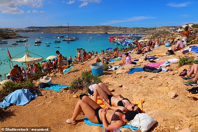
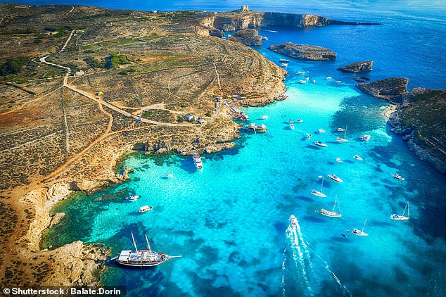
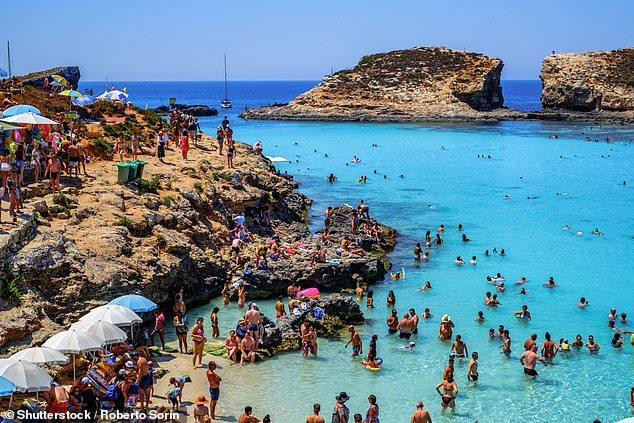
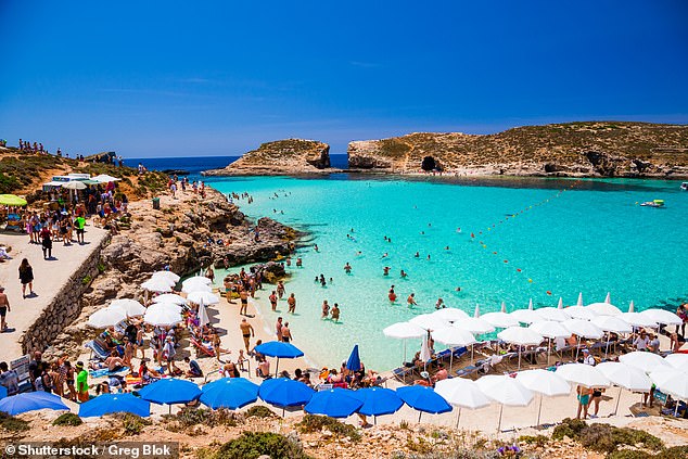
Around the globe, the small Maltese island of Comino has earned recognition for its stunning turquoise waters and its well-known limestone beach called the Blue Lagoon.
The charming island’s appeal has grown thanks to social media influencers visiting Comino for the ideal photo opportunity and due to its feature in popular Hollywood movies like Troy.
Nevertheless, even though Malta’s tourism board calls it the ‘most beautiful location in the Mediterranean,’ Comino is currently suffering from excessive tourist traffic.
Throughout the summertime, as many as 10,000 visitors arrive daily by boats, only to be squeezed into the crowded bay.
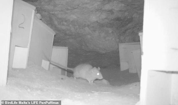
Impromptu bars blaring loud tunes encircle the attendees offering alcohol and finger foods, only to have these items discarded as trash, thus becoming a readily available meal for Comino’s rapidly growing rodent populace.
Activists in Malta are currently battling to safeguard Comine, designated as a protected natural reserve and avian sanctuary, against potential destruction.
A civic organization called Movimento Graffiti is advocating for significant reforms in how the island is governed.
In 2022, they organized a large demonstration during which they took control of and removed sun loungers and umbrellas.
A participant from the group referred to the present circumstances as ‘intolerable’, according to Andre Callus.
‘The residents of Gozo and Malta consider it a nightmare, so they avoid going there now. Commercial enterprises have completely overtaken Comino. Despite being a tiny location, there are 11 kiosks selling food and drinks. Their primary aim seems to be maximizing profits from the island,’ he explained.
The Daily Telegraph
.
Maltese non-governmental organizations (NGOs) claim that a study assessing the number of tourists the island can accommodate was suppressed by the Maltese authorities. However, numerous residents clearly observe the adverse effects of overcrowding due to tourism.
Residents of the tiny island nation took to writing letters to local newspapers criticizing the current condition of Comino.
One remarked that the once-famous Blue Lagoon now resembled “a dilapidated favela in some neglected nation.”
Someone else commented: “This formerly picturesque island has transformed into a circus, and I would not visit it again even if someone offered me money.”
The Maltese government is attempting to carefully navigate the space between safeguarding the natural allure of Comino and fostering Malta’s tourism industry — an industry that constitutes 15 percent of the nation’s gross domestic product.
Ian Borg, who serves as the minister for tourism, suggests reducing the daily visitor limit to half, dropping from 10,000 to just 5,000 individuals permitted to explore the island each day.
In order to implement this legislation, the authorities must verify with commercial boat owners the number of passengers they transport and the frequency of their daily trips.
Mr. Borg has additionally committed to reviewing the permitted number of bars operating and installing public restrooms.
Nevertheless, organizations like BirdLife Malta advocate for Comino’s designation as a nature reserve to be upheld, which includes removing waste every day and limiting visitor numbers.
Comino symbolizes the broader challenges posed by tourism for Malta; this small country with a populace of slightly more than 500,000 experienced an astounding 3.6 million tourists visiting last year.
To cater to visitors, extensive shoreline projects have been greenlit, but activists argue these initiatives are causing irreparable harm to Malta’s natural surroundings.
Mark Sultana, CEO of BirdLife Malta, wishes that the condition of the Blue Lagoon serves as an awakening for both politicians and developers.
“The cow has been milked excessively,” he stated.
Read more

by admin | Mar 31, 2025 | marine animals, natural disasters, nature, tourists, wildlife
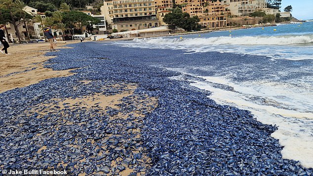
An unusual natural phenomenon has resulted in a beach in Majorca being blanketed with a gooey blue substance.
Both locals and tourists didn’t find their usual golden sandy shores when they woke up today, transforming what typically draws many visitors to the Balearic islands into something quite different.
Rather than what they expected, they encountered coastlines in Port de Sóller covered with countless slippery blue entities.
A clip capturing this bizarre event reveals increasing amounts of odd formations being hurled onto the beach by the ocean currents.
Even though this observation appears as if it’s out of this world, there is actually a completely terrestrial explanation for what we’re seeing.
The unusual-looking creatures are actually By-the-wind-sailors, which frequently get swept onto land due to powerful winds.
FaceBook
Jake Bullitt noticed a By-the-wind-sailor jellyfish on the shore and posted about it online.
He mentioned that countless tiny Velellas, also known as By-the-Wind-Sailors, had been washed up at the western edge of the bay, with even more continuing to wash ashore.
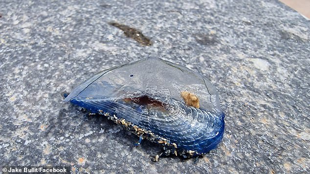
Even though they share an uncanny resemblance to the Portuguese man o’ war — known for its painful stings — By-the-wind-sailors pose little threat to humans, as their sting typically causes only minor skin irritation.
The problem these beaches in Majorca currently encounter is dealing with the deceased marine life. If left unremoved, these organisms can begin to decompose, producing an unpleasant smell and drawing flies.
By-the-Wind-Sailors are commonly found in warmer waters during the spring and winter seasons.
Their names originate from their unusual form, which looks like a ship’s sail.
True to their namesake, jellyfish traverse the globe in groups with their ‘sail’ assisting them during these journeys.
Throughout their voyage, the By-the-wind-sailors employ their tentacles and stingers to hunt smaller creatures and juvenile fish.
Read more
by admin | Jan 6, 2025 | ecology, heritage, monuments, nature, tourist attractions
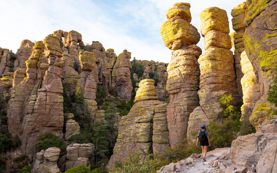
Situated in southern Arizona, Chiricahua National Monument draws both nature enthusiasts and passionate hikers because of its stunning and seemingly weightless rock structures.
At Chiricahua National Monument, the hoodoos, which the Apache affectionately refer to as “standing-up rocks,” create an astounding stone forest shaped over time through relentless erosion. This spectacle must be witnessed firsthand to truly appreciate its magnificence.
To get the perfect view, drive along Scenic Road, a twisting path through a verdant valley filled with pine trees and junipers. This route will lead you to the most spectacular sights within the park. Start at the Organ Pipe Formation; here, erosion has sculpted cliffs into distinct vertical pillars resembling organ pipes. Proceed onward until you arrive at Massai Point, offering panoramic views as far-reaching as those seen over a stone-built metropolis, evocative of New York City’s skyscrapers. To gain yet another extraordinary viewpoint, tackle the steep but rewarding trail leading up to Inspiration Point—a journey that winds past clusters of rhyolite columns before culminating in awe-inspiring panoramas across the entire national park. If easier hikes appeal more, try out Echo Canyon Loop, a three-mile circuitous trek marked by numerous caves and striking landforms. Alternatively, for something shorter, walk towards Echo Canyon Grotto via a less strenuous 0.8-mile round trip. You’ll be left astounded by this incredible natural landscape!
Chiricahua National Monument
12856 East Rhyolite Creek Road
Willcox, AZ 85643
+1 520 824 3560
https://www.nps.gov/chir/index.htm

by admin | Dec 12, 2024 | hiking, nature, tourist attractions, Travel, waterfalls
The natural pools and petrified cascades of Hierve el Agua offer a dreamscape for a relaxing dip and spectacular hikes.
Picture a scene where rocks appear to stream like liquid down the side of a cliff, solidified into white falls through hundreds of years of limestone buildup. This is what awaits you at Hierve el Agua, roughly a two-hour drive away.
Oaxaca
, where two gigantic petrified cascades plunge into the void, like waterfalls frozen solid. These limestone formations result from mineral springs rich in calcium carbonate, which have slowly sculpted these fascinating reliefs.
Take a plunge in the turquoise-hued pools suspended at the edge of the void. Slightly saline, the water, fed by effervescent underground springs, is renowned for its relaxing properties. To explore fully, take the one-and-a-half-hour walk that leads you around the cascades and down to the foot of these geological sculptures. Between giant cacti and desert landscapes, every twist and turn of this trail brings you closer to the wild heart of this region of Oaxaca.
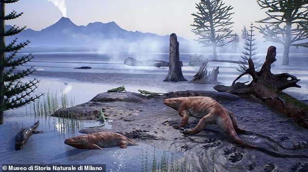
by admin | Nov 20, 2024 | archaeology, ecology, nature, paleontology, science
-
READ MORE:
80-million-year-old dinosaur eggs found in China
A 280-million-year-old hidden realm was inadvertently uncovered by a
a woman during her hike in the Italian Alps
.
When Claudia Steffensen and her spouse were hiking through the Valtellina Orobie Alps National Park in Lombardy back in 2023, she noticed a pale grey stone adorned with peculiar patterns.
As she took a closer look, she recognized that the patterns were indeed footprints of animals.
Steffensen forwarded images to a group of researchers who concluded that the tracks were from
a ancient reptilian creature that traversed the planet
During the Permian era, which came right before the time of dinosaurs.
Upon further exploration of the area, palaeontologists uncovered hundreds of additional fossilised tracks created by at least five different species of prehistoric reptiles, amphibians, and insects.
Although these creatures lived before the time of dinosaurs, some must have reached significant dimensions, possibly measuring from six to twelve feet in length, according to researchers’ statements.
The group similarly discovered impressions of plant fossils—ranging from remnants of seeds, leaves, and stems—together with marks left by raindrops and waves upon the ancient lakeshore.
Lorenzo Marchetti, a co-re searcher and specialist in trace fossils from the Museum of Natural History,
Berlin
mentioned that the prints were maintained with ‘remarkable’ clarity, including details like ‘fingernail marks and the stomach skin of certain creatures.’
The intricate details and exceptional preservation of these fossils can be attributed to their close vicinity to water, as the researchers pointed out.

The old ecosystem, which exists at elevations up to 10,000 feet and within valley floors, has been conserved in finely layered sandstone.
Palaeontologists likewise recognised claw marks and imprints from the undersides of these creatures.
“The tracks were formed when these sandstones and shales were merely wet sand and sediment along riverbanks and lake edges, where seasonal fluctuations would cause periodic drying periods,” explained co-researcher and paleontologist Ausonio Ronchi from the University of Pavia.
statement
.
Ronchi mentioned, ‘The summer sun dried out those areas, making them so hard that when fresh water returned, it didn’t wash away the footprints; instead, they were coated with a new layer of clay, providing protection.’
The Permian epoch extended from 299 million to 252 million years ago.
At this juncture, the worldwide climate swiftly heated up, culminating in a major extinction episode that signalled the close of this era and wiped out 90 percent of life forms on Earth.
Paradoxically, contemporary global warming facilitated the unveiling of this ancient alpine habitat, since the remains were concealed beneath snowpacks that have thawed due to the increased temperatures on Earth.


“The finding in the Ambria Valley can be attributed to climate change as well,” said Doriano Codega, who serves as the president of the Valtellina Orobie nature park.
The Guardian
.
The remarkable aspect was the elevation – these artifacts were discovered at considerable heights and were remarkably well-preserved. The region experiences frequent landslides, leading to rock dislodgments which unearthed these fossils.
From 1850 onwards, due to human-induced climate change, Alpine glaciers have experienced a reduction of 30 to 40 percent in surface area and about half of their total volume, with an extra loss of 10 to 20 percent occurring since 1980, as reported.
CREA Mont-Blanc: Research Centre for Alpine Environments
.
This finding provides insight into an old environment destroyed by severe global temperature increases. Consequently, it also acts as a warning about the consequences we face as human-induced heating approaches critical points.
“These fossils … provide evidence of a far-off geological era, yet they showcase a pattern of global warming that closely mirrors what we see today,” the researchers stated.
‘The past holds many lessons about the risks we face in shaping the world today.’
Read more